Zenmuse L3

Overview

This advanced aerial LiDAR solution delivers extended measurement capability, reaching distances of up to 950 m¹ even when scanning surfaces with low reflectivity (around 10%). Paired with dual 100 MP RGB mapping cameras and a high-accuracy positioning system, it supports fast geospatial data capture, allowing operators to map areas of up to approximately 100 km² per day².

Dual 100MP RGB Mapping Camera System

High Penetration

Up to 100 km² per Day

End-To-End Solution

DJI Care Enterprise

High Accuracy

1535nm Long-Range LiDAR

High Accuracy

Proprietary High-Precision System


With a refined POS system capable of 0.02° heading and 0.01° pitch accuracy (post-processed, 1σ), and a LiDAR achieving 5 mm repeatability at 150 m⁵, this platform is built for dependable survey-grade results. Microsecond-level synchronization and comprehensive factory calibration further ensure stable and accurate data output.

Focused Beam, Enhanced Power

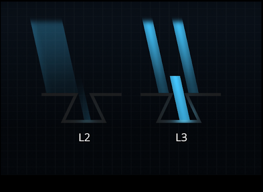
A narrow 0.25 mrad (1/e²) beam divergence produces a much smaller spot size—roughly one-fifth that of the Zenmuse L2 at equal distance—allowing the system to identify fine features such as utility wires and small branches. The higher energy concentration improves penetration through vegetation, increasing ground point density and supporting precise reconstruction of detailed terrain and structural features.

1535nm Long-Range LiDAR

High-Reach Sensing for Efficient Mapping

Capable of reaching up to 950 m¹ at a 100 kHz pulse rate—even in strong ambient light and on low-reflectivity surfaces—the sensor adapts to mission needs through its adjustable pulse settings. Recommended operating altitudes of 300–500 m³ allow wider swaths to be captured per flight, significantly increasing daily mapping output.

High-Speed Laser Output with Flexible Return Handling

Delivering up to 2 million pulses per second and accommodating 16 returns⁴, the system produces rich point-cloud data for accurate modeling. Adjustable density and penetration settings allow it to perform effectively in both open areas and dense, obstacle-filled environments.

Flexible Scanning Options

Choose from three scanning styles depending on the application:

  • Linear for consistent, survey-grade point distribution.
  • Star-Shaped for balanced accuracy and multi-angle penetration in forests or dense environments.
  • Non-Repetitive for maximum angle variation and extended coverage, ideal for power line inspection and detailed structural analysis.

Dual 100MP RGB Mapping Cameras

Equipped with two 100-megapixel RGB mapping cameras, the system delivers a wide horizontal field of view of up to 107°, enabling each image to span a larger area. With only a 20% LiDAR side-overlap requirement, operators can collect data for both digital orthophotos (DOM) and digital elevation models (DEM) during the same flight, significantly increasing overall mapping efficiency.

High-Precision LiDAR Results

Vertical accuracy is better than 3 cm at 120m altitude, better than 5 cm at 300 m, and better than 10 cm at 500 m [6], easily supporting mapping projects at 1:500, 1:1000, and 1:2000 scales. The point cloud thickness produced by Zenmuse L3 is only half that of Zenmuse L2, supporting advanced analysis and high-accuracy applications.

High Efficiency

Request for a Quote