Harness the power of drones to capture critical visual and thermal data, enhancing prevention strategies and response tactics during natural disasters, including floods, landslides, earthquakes, and more.
Painpoints
The absence of updated terrain information and situational awareness can severely hinder an effective response.
Advantages
Provide critical terrain analysis and situational awarness through updated digital models and real-time aerial imagery.
Entering a disaster zone without real-time updates can leave response teams blind to evolving conditions.
Ensure safety and proper allocation of response personnel with continuous drone-based aerial support.
Traditional data collection methods for post-disaster recovery struggle to grasp the full scope of damage and determine the necessary resources required for efficient rehabilitation efforts.
Conduct comprehensive impact assessments and streamline rehabilitation efforts using precise, easily shareable digital models.
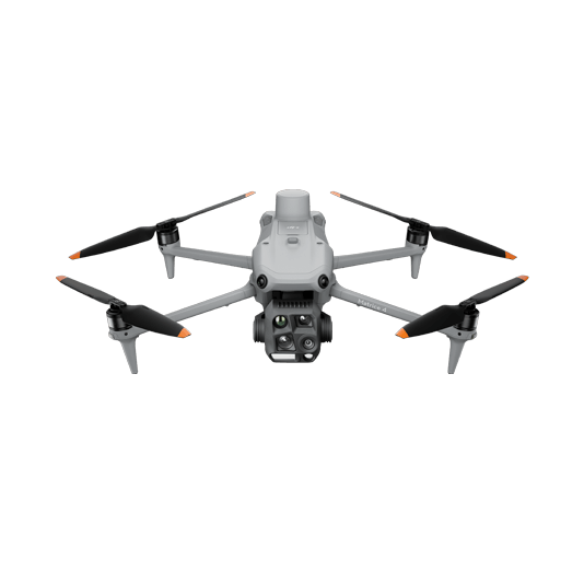
The Matrice 4T offers unparalleled portability for quick deployment missions. Easy to carry on fire response vehicles and equipped with visual and thermal cameras, it’s the ideal solution for initial risk evaluations.
Compact and lightweight design, around 1.2 kg and easy to carry in the response vehicle.
Fast and easy deployment, get airborne in around 30 seconds.
640 × 512 thermal radiometric sensor for accurate temperature readings.
Thermal palettes and temperature measurement tools for easy data interpretation.
Mission Execution: – Fly manually over the affected area looking for hotspots. Switch between infrared and visual views to evaluate the situation. – Use orbit flights to perform 360 circular flights around the structure, facilitating the risk evaluation. – Select a suitable infrared palette and gain mode for the conditions at hand.
Post Mission Documentation: – Map the affected areas for post-incident reports and reforestation efforts.
Versatile Aerial Thermal Reconnaissance
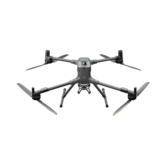
The Matrice 30T strikes the perfect balance between portability and performance. It integrates a hybrid sensor with visual, thermal, and laser range finder capabilities for optimal performance in a variety of disaster conditions.
Rugged, weatherproof mid-size airframe, provides balance between portability and endurance.
640 × 512 thermal radiometric sensor for accurate temperature readings.
Get coordinates of critical points through the laser range finder sensor.
Dual camera views for comprehensive situational awareness.
Mission Execution: – Fly manually over the affected area looking for hotspots. Switch between infrared and visual views to evaluate the situation. – Use the Link Zoom feature to zoom in simultaneously with thermal and visual sensors. – Get the coordinates of hotspots using the laser range finder and the Pin Point function or draw out routes and areas to avoid. – Share Pin Point coordinates to ground teams through DJI Pilot 2 QR code or DJI FlightHub 2.
Post Mission Documentation: – Collect the videos and photos captured during the mission through DJI FlightHub 2 or download from the drone SD card to be used as supporting documentation for post-disaster analysis.
Portable Pre and Post Disaster Mapping
The DJI Matrice 4E is a portable surveying and mapping drone suitable for single-pilot operations. Paired with DJI Terra, it can generate accurate 2D and 3D models that can be used for prevention or post-disaster efforts.
Portable solution, easy to carry and deploy.
Centimeter-level data thanks to its mechanical shutter and RTK capability.
Field-work efficiency—covers 2.8 km² per flight.
Real-Time Terrain Follow feature to ensure high-quality data capture in challenging and variable terrains.
Data Collection: – Plan a 2D or Smart Oblique Mission based on the actual landscape situation to generate regular orthomosaic images or 3D Models.
Data Processing: – Import to DJI Terra to process orthomosaic maps or 3D models.
Data Analysis: – Perform analysis on the situation directly in DJI Terra or import the outputs to the preferred third-party software for further analysis.